
The Warbler Road: Overview and Strategy
Despite having lived in central Virginia for a few years now, and spending a good amount of time in the Blue Ridge Mountains, somehow I only recently heard about the Warbler Road! Of course, after learning about it I had to check it out for myself. I thought a blog post with an overview, some tips, and some details from my first Warbler Road adventure might come in handy!
The Warbler Road isn’t a single road, and as far as I can tell it’s not even really an official thing (the Virginia Department of Wildlife Resources does have a couple useful pages about it, but there’s no Warbler Road signage or anything along the route itself). It’s actually a route running about 14 miles along several Forest Service roads, running through the Washington & Jefferson National Forest between the small town of Arcadia at the west end to the Blue Ridge Parkway’s Sunset Field Overlook (near the highest point of the Blue Ridge in Virginia) at the east end. The route covers over 2,600 feet of elevation change from one end to the other, traversing mountain forests, rivers and creeks, open meadows, and more.
The combination of varied habitats, range of elevations, and few people makes the stretch very active for wildlife–and in the spring, it’s a hotspot for many species of migrating birds, especially warblers. Hence the name! A big perk of the Warbler Road is that as the mountain roads wind upwards, you’re at eye level with the upper branches of trees on the downslopes, where many of those elusive little birds prefer to loiter.

It’s possible to begin the route from either end, of course, but I suggest starting at the western end, arriving at the Arcadia Boat Launch as early in the morning as you can manage. That’s the lowest point of the route, so you’ll find birds active near the James River. Then, as you climb up the rest of the route, the temperatures will stay moderate and the birds will remain more active.
I’ve seen it mentioned elsewhere that a 4-wheel-drive vehicle is recommended, and maybe that’s the case in inclement weather, but I didn’t come across any particularly challenging terrain. The majority of the route’s roads are crushed gravel, but I was never concerned about traction or clearance, and didn’t come across any stream crossings or anything like that. The mountain roads are certainly narrow and winding, so taking it slowly and carefully is recommended, but I also found plenty of wider spots to pull off to the side. I went on a weekday so traffic was very light; I played leap-frog with a couple vehicles going in the same direction, but never encountered anyone going the other way.
Stop #1: Arcadia Boat Launch and Jennings Creek


The Arcadia Boat Launch is a gravel parking lot with a path to the James River. There are some very nice scenic views here, of the river and the Route 614 bridge. You’re likely to spot birds flying in and out from under the bridge, and in the trees on either side of the river. Also check out the field next door, and the trees across the road. At this spot I saw Indigo Bunting, Eastern Phoebe, and some ducks passing overhead.
Turn right out of the boat launch lot onto route 614. About a half mile down the road is a bridge over Jennings Creek–this isn’t a bad place to stop to check out the creek, and the stretch of road between the bridge and railroad tracks. Birds can be active in these woods and fields as well.
Stop #2: Solitude Road and Swamp


West of the railroad tracks on route 614, watch for a narrow dirt track on the left, called Solitude Road. This is a scenic lowland stretch (though a bit hazy on my visit) with some lovely views of farms and mountains. Past a gorgeous large farm and wooden fence, watch for a swampy stretch on the right side of the road–this is a good spot to look for wetland warblers and cuckoos. I didn’t see any of those, but across the farm fields I spotted an Eastern meadowlark and Indigo bunting, and came across a cute Eastern chipmunk crossing the road!
Double back to route 614 and turn left, proceeding east again. Across from the sign marking the boundary of the Jefferson National Forest, there’s a fantastic little waterfall along Jennings Creek, well worth a short visit. The intersection of route 614 and FS 59 is another good place for a short stop–I found lots of birds and butterflies along the creek here.
Stop #4: North Creek Campground and Whitetail Loop Trail

From route 614, take the left turn onto Forest Service Road 59 (N Creek Rd). This road meanders alongside North Creek, so keep an eye out along the creek if you can–I spotted a Common merganser resting on a rock in the creek, and there were scads of butterflies all over.
The North Creek Campground area is a good place to stop to look for birds. After being in the car all morning, I took the opportunity for a leg-stretching hike on the Whitetail Loop Trail, which has a small parking lot along FS 59 just past the campground. The trail offers two options, a short loop (0.75 miles) or a long loop (1.75 miles), both traversing some nice forest land without too much elevation gain (read: fairly easy hiking). I heard more birds than I saw here, but spotted some good ones like an Ovenbird and some warblers.
Stop #5: Warbler Central (FS 768 and FS 812)


This one isn’t a stop, but rather the main attraction of the Warbler Road–the winding gravel forest roads heading up into the higher elevations, which I think of as Warbler Central. You’ll likely want to stop frequently as you make your way through this stretch–keep your car windows down and listen for the birds! I came across Cerulean and Hooded warblers, both rarities in my book. Lots of other birds to be heard and seen as well–pretty much everywhere I heard Ovenbirds and American redstarts, among other things. Also great opportunities for scenic and macro photography: spring flowers, bugs, etc.
One place you’ll definitely want to pause is Parker’s Gap, the intersection of FS 812 and FS 3034. There’s a powerline clearing that’s pretty active with bird activity. Here again I heard American redstarts, and I was able to draw a couple out for some nice photos.
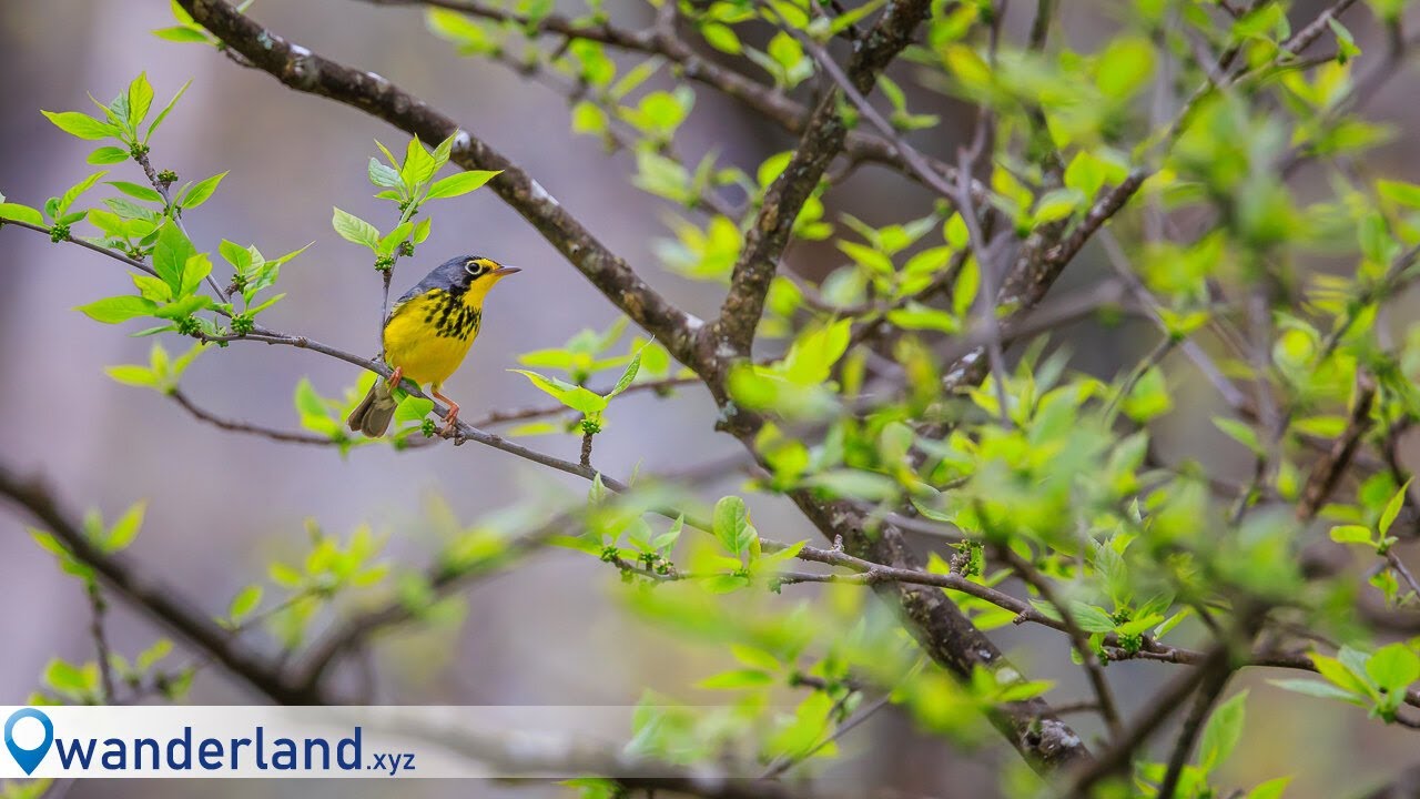
Stop #6: Tower Road and Sunset Field


Just before reaching the Sunset Field/Apple Orchard Falls Trailhead parking area, you’ll see a road leading off to the left. That’s Tower Road, which leads towards a radio tower and radar station atop Apple Orchard Mountain. It’s another very active stretch for birds, and it’s where I found the treat of the day: some beautiful Canada warblers.
You can drive Tower Road for about a half mile, but will discover the rest is gated. You can turn around at the gate and park along the road, and then walk the stretch of road beyond the gate. This was another good stretch, where I found Black-and-white and Yellow-rumped warblers, another American redstart, plus several different species of butterflies on the abundant spring flowers.
Backtrack to the Sunset Field/Apple Orchard Trailhead parking lot, and look around there for more birds. Here I spotted Brown-headed cowbirds foraging in the grass, and a Northern catbird calling near the treeline.
Bonus Stop: Blue Ridge Parkway James River Visitor Center


From Sunset Field, you have a choice. You can take the Blue Ridge Parkway southwest towards the Peaks of Otter, or northeast towards the James River Visitor Center. Either way you’ll find majestic Blue Ridge views, of course, and plenty of options to continue your adventure. I headed towards the James River Visitor Center, which I’d never visited before. And it was a real bonus treat!
From the visitor center building (sadly closed on my visit), there’s a walkway to a pedestrian bridge slung underneath the Blue Ridge Parkway bridge over the James. This was a hotspot for Cliff swallows, many of whom construct nests under the bridge–such a great opportunity to get close enough to get good photos of Cliff swallow heads poking out of nests! Also fun time to practice birds-in-flight shots as the swallows swooped all around the bridge and river. Across the bridge I also spotted more great birds: Tree swallow, Eastern bluebird, Baltimore and Orchard orioles. And the trail runs along the river to a restored section of the Kanawha Canal, which was interesting to check out.
Final Tips
My first Warbler Road adventure was a fantastic day, and for birders and photographers and nature lovers I definitely recommend checking it out! Some final tips:
• To reiterate: You can start from either end of the route, but I suggest starting at the Arcadia end so you’re climbing as the day goes on. That will keep the temperatures cooler and the birds more active as you proceed. On the day I went, everyone else seemed to have the same thinking, so I didn’t have to navigate any oncoming traffic.
• Take the drive slow! For safety because much of it is narrow, winding roads with blind curves, but also because you’ll want to keep your eyes and ears peeled for the birds you’re after, and be able to stop quickly when you see/hear them.
• There’s really nothing out there in terms of amenities or civilization, so make sure you bring everything you need: Plenty of gas, drinking water, meals and snacks, and some way to tend to nature’s call, if you catch my drift. The North Creek campground has chemical toilets, but that’s about it. Happily, I did have at least weak cell phone service all the way, so navigation shouldn’t be a problem–still, if you can have a paper map and/or download offline maps, better safe than sorry.
• Insect repellant wouldn’t be a bad idea. I didn’t encounter mosquitoes or other biting insects, but there was certainly a cloud of gnats everywhere (and I forgot the repellant!). By the same token, if you venture off road at all, watch for ticks–I picked off a few before they found anywhere to latch on.
• As far as birding goes, expect to hear more than you see. The Merlin app is helpful to identify the songs you’re hearing, and let you know what you’re looking for. But even though you’re up in the trees with them, a lot of the birds just know how to keep their distance. They’re out there, though!